
New Glen, Victoria County
46N12.797 60W47.552
20T E670269 N5120113
RIVER: Falls Brook
CLASS: cascade
SIZE: 50 feet
RATING: excellent (****)
TRAIL: improved trails
DISTANCE: 3km
HIKING TIME: 1.5 hours
CONDITIONS: moderate

photo Robert Pierrynowski (2008)
NS Atlas Page: 13/X1
NS topo page: 011K02 (Baddeck)

photo Sylvia Fisher (2011)
DRIVING DIRECTIONS: from Baddeck, take EXIT9 off HWY105 (TCH) northward onto Margaree Road. Drive 4km along this road then turn right onto West Side Baddeck Road. Follow this road 6.4km and turn left onto North Branch Road. Drive another 3.5km to Uisge Ban Provincial Park.

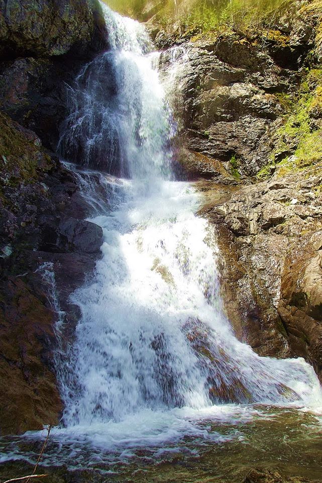
(lower falls)
TRAIL DESCRIPTION: follow trail signs to trail head within the provincial park and follow the improved trails upstream along Falls Brook some 3km to the falls. This trail travels thru a mature "climax hardwood" forest full of sugar maples, yellow birch and beech trees. There are many interesting "captured stones" along the way, massive tree roots that have grown around large boulders giving the area a mystical feel.

(approaching the falls)
When you reach the falls, you will be amazed by these fifty foot falls, with sheer 500 foot canyon walls soaring above the falls on either side of the waterfall. Popularly called "Uisge Ban Falls", the official name according to the Canadian Geological Database is Easach Ban. The name is Gaelic for "white water". These are incredibly popular falls and you will often meet fellow hikers along the way.

photo Sylvia Fisher (2011)
The Provincial Park is a Day Use park which closes its gates at dusk, so keep aware of the time. The park itself has picnic facilities. The trail was originally constructed by the Nova Scotia Forest Technicians Assosciation and recent improvements have been handled by Stora Enso and the Nova Scotia Department of Natural Resources. A true gem in the heart of Cape Breton.

(trail map at the park)
Another falls, about 30' in size, exists a further 1.5km upstream from Easach Ban Falls for the super adventurous. Just continue hiking up along the side of the brook. Access to the top of the ridge above the falls can be had several hundred meters back downstream, and as usual, be cautious around the high cliffs around this location.

photo Ken Heaton (2012)


I think you may have meant uisage ban falls, it is probably gaelic, hard to spell
ReplyDeleteOfficial Spelling "Easach Ban" http://www4.rncan.gc.ca/search-place-names/unique.php?id=CAKIL
ReplyDeleteOddly the name for this falls is spelt several different ways, even by the Nova Scotia Government. Check the spelling on trail map and on each of these sources linked below:
http://www.novascotiaparks.ca/brochures/Victoria_Hiking.pdf
http://www.trails.gov.ns.ca/shareduse/vi012.html